


Great Rollright: a village of farmsteads
An interview with local history researcher Carol Dingle

What was the built character of Great Rollright in Oxfordshire in the early 19th century when shepherd Richard Widdows first moved there as a boy? To respond to this question, I enlisted the help of local history researcher and author Carol Dingle. Carol has spent the last two decades researching the history of the village, transcribing documents held in the extensive archives of Brasenose College and writing a book on Great Rollright’s farmhouses and cottages.
Farmsteads and manorial estates
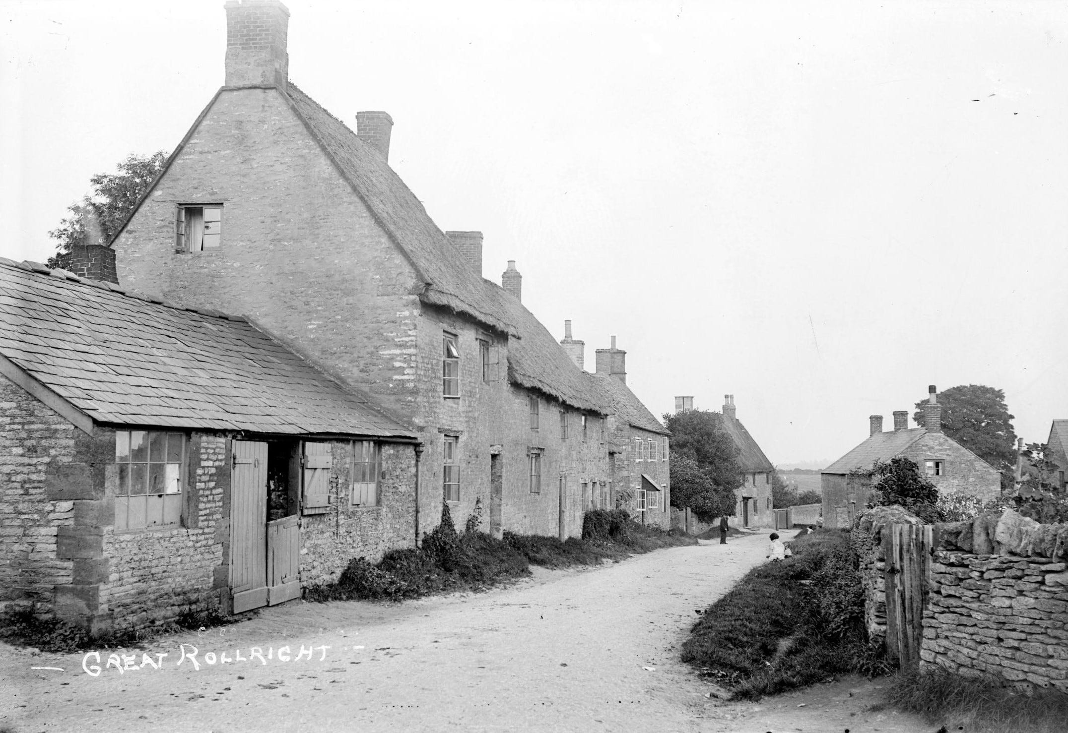
When Richard Widdows arrived in Great Rollright as a plough boy at Coombe Farm in about 1821, the village had a population of 419 and over 90 dwellings. It was almost four times the size of Burmington, the village near Shipston-on-Stour where he was born.
Situated on a ridge of high ground about 200 metres above sea level, Great Rollright was then a very isolated rural parish. Often referred to as the ‘windy village’, it is almost three miles north of Chipping Norton and a similar distance from Hook Norton to the south-west. As Carol highlights, as ‘a community it was by necessity self-sufficient with the exceptions of coal or salt. In her book, she describes how from the 1840s, yeoman farmer Benjamin Robinson acted as village carrier and ‘transported agricultural products as well as poultry, game, rabbits, eggs, and fruit to Chipping Norton to tradesman on Wednesdays and Banbury on Thursdays, both market days. On his return journey he would bring goods required by the villagers, including tea, hardware, tobacco, lamp oil, knitting wool and crockery, often supplying the village shops.’
Unlike many villages that are clustered around a single ‘big house’ or manor, Great Rollright was spread out. It’s open, loose-knit form was centred around farmsteads and distinct ‘ends’. This dispersed quality would have been even more marked than it is today without the infill of 20th-century housing. In The Manors and Advowson of Great Rollright (1927), historian Reginald W Jeffery describes the village’s dwellings as seemingly have ‘run away from the church’; the Norman church being the original site of settlement. Great Rollright developed around manorial holdings and their farmsteads. By the 1820s, the village had taken the shape it is now with original timber structures being replaced with local limestone. Most of the cottages were thatched: only two or three roofs remain thatched to this day.
As Carol points out, ‘every building, with the exception of the church, rectory and Unicorn pub, had an agricultural function, whether it was a farmhouse or cottage, accommodating agricultural labourers and their families, or the workshops of the wheelwright and blacksmiths’. Nonconformity took hold among the inhabitants of the village at this time with ‘cottages licensed for worship in 1821 and 1836, and a barn (occupied by the farmer John Berry) in 1837’.
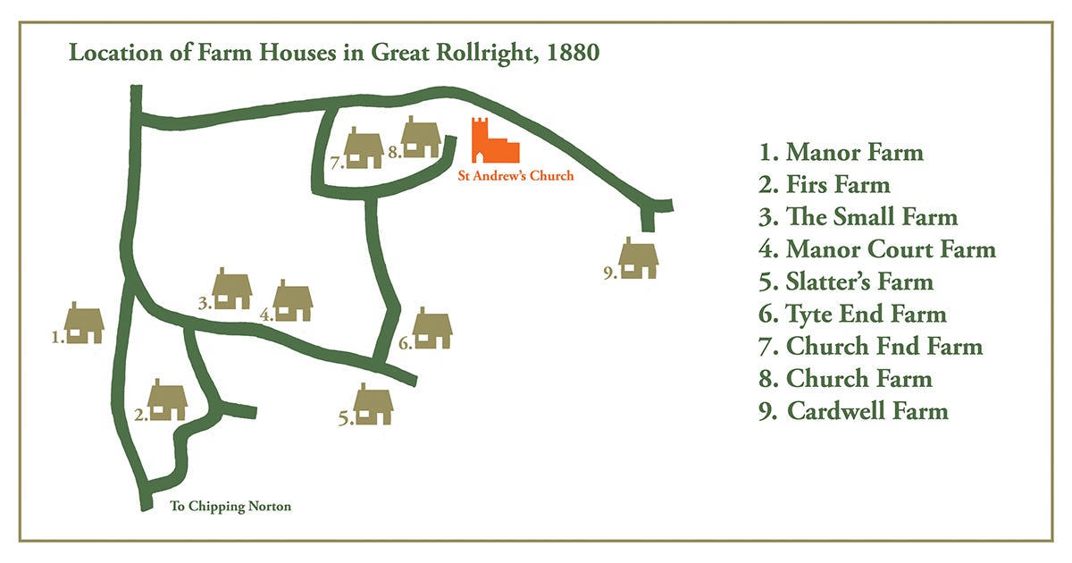
At the beginning of the 19th century, there were no resident landowners. The 2,000 or so acres surrounding the villages were largely divvied up between Brasenose College and Great Rollright Manor. As Carol describes in her book: ‘The college owned Church End Farm, Church Farm, Tyte End Farm and Manor Court Farm’ and adjacent smaller farms. ‘Farming land was usually let to tenants by twenty-one year leaseholds … As the manorial owner of its land in the village the College held manor courts usually twice a year to control the administration of land and settle disputes.’ These were convened at Manor Court Farm, the biggest farmstead that Brasenose owned, declining in regularity after enclosure. According to Jeffery, the last three courts were in 1857, 1885 and 1908. Widdows’ employer, tenant farmer William Fletcher, lived with his family at Manor Court Farm from 1855 until 1880. Jeffery describes every rector between 1598 and 1907 as ‘a Brasenose man’, a graduate or fellow of the college. During the 1800s, the Hall family who owned the Great Rollright Manor estate leased it to the Berry family, who lived in Church End Farm. It was not until 1898 that a member of the Hall family, Major AC Hall, became a resident of the village.
Widdows spent his working life in the area to the north-west of the village. A good mile’s walk from the centre, it is in a separate valley known to the locals as ‘coombe’ or ‘coombs’. It was the site of two separate farmsteads: Coombe Farm, where Widdows first worked as a plough boy for tenant farmer Thomas Harbidge in the early 1820s, which was owned by Great Rollright Manor; and Fletcher’s Coombs, a small homestead farmed by William Fletcher for Brasenose College. Widdows worked for Fletcher as an agricultural labourer and shepherd from the 1830s to late 1870s. (Neither farms are marked on the map.)
The road pattern and enclosure
It isn’t just the buildings that give Great Rollright its distinct character, as Carol points out, it is also the vein-like patterns of the roads that link the farmhouses: ‘The survival of the village’s shape post enclosure, which took place in 1776, is due to the resolve of the villagers, who got together and insisted none of the internal roads were changed.’
Three commissioners were appointed to undertake the enclosure of land at Great Rollright: Francis Burton of Aynho, Thomas Browne of Cowley and John Watts of Sulgrave. Declining to stay at The Unicon pub in the village, they resided at the superior Chapel House Inn on the Oxford Road, closer to Chipping Norton. During her research in the Brasenose archives, Carol found a bill two A4 pages long, which was presented to Brasenose College by a Mr Richard Shortland. It itemised the work he carried out (at 1 guinea a day) from January 1775 to August 1776 and his visits to Chapel House Inn, mentioning a meeting with two of the commissioners – Mr Burton and Mr. Watts at Chapel House – to ‘consider about the allotments’ (presumably allocation of land). The total bill comes to £54.12.0d (about £10,000 in 2024). A further bill submitted by Shortland for fences, gates, timber, surveyors etc, including the £54 .12. 0d, comes to a staggering £981. 7s. 3d (over £200,000 today).
Landholdings were divided up between the major landowners, whereas previously: ‘the land adjacent to the village was farmed by the two- or three-field system, with all of the land outside the manorial demesne lands divided up annually’. The commissioners also granted to Surveyors of the Highways in 1776 ‘three stone and gravel pits and in 1811 spent £100 repairing the roads to Hook Norton’. The limestone surfaced roads of the village remained, beyond the closure of the pits in 1890, until their replacement by tarmac in the mid-20th century.
Hovels to homes
To Widdows, as a boy living at Coombe Farm and working outdoors all day, the interior shelter offered by a house would have been more significant than the exterior appearance of the village. As Carol emphasises: ‘farmhouses at this time were places of work, not places of relaxation or pleasure. Furniture was limited to a few wooden items. There were no easy chairs.’ As a plough boy, he might have slept in a garret in the roof or even an outbuilding. A reporter from the Oxfordshire Weekly News, interviewing Widdows about his life when he was in his mid 90s in October 1905, from the comparative comfort of the Edwardian era, looking back at his late childhood in Rollright in Georgian times, wrote: ‘He speaks of the improvement in the houses as the most noticeable feature. At the time of his youth some of the dwellings were little more than hovels, which might at present day be used as pigsties.’
Carol Dingle has lived in the village of Great Rollright for 36 years. She is a local history research and author of Farmhouses and Cottages of Great Rollright: A Look at the Changes to the Eighteenth Century Village Farmhouses and Cottages and a Glimpse of the Lives of Some of the Occupants, 2022. She has also undertaken individual studies of some of the most significant historic buildings in the village, such as 17th-century Duck End House.